A Tornado driven HIGH Risk has been issued for Oklahoma/Kansas
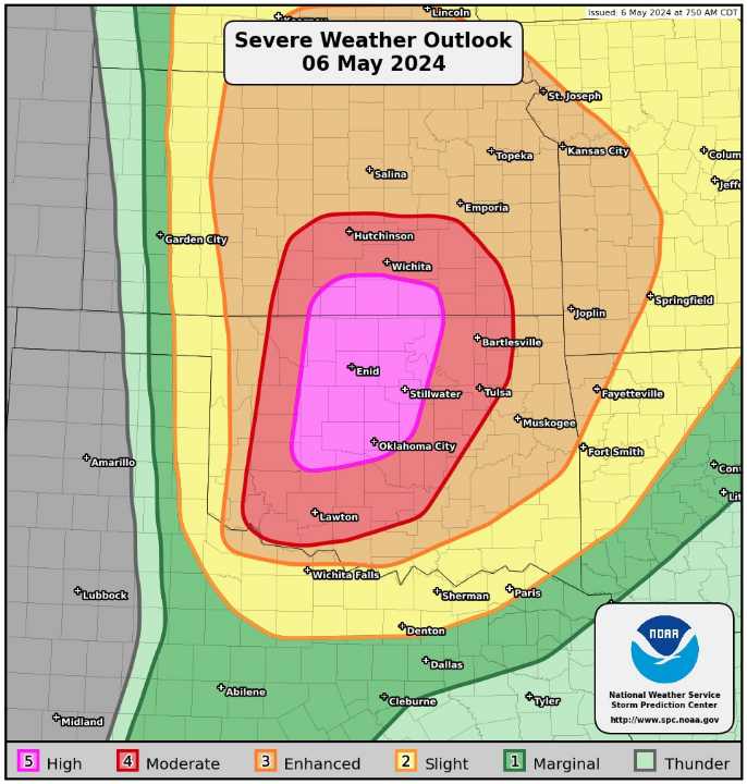
A regional outbreak of severe weather with multiple strong, long-tracked tornadoes, as well as very large hail and severe thunderstorm gusts, is expected over parts of the south-central Plains from this afternoon through evening.

Severe thunderstorms are likely to form in the mid to late afternoon along and ahead of the dryline, starting near the eastern Texas Panhandle and western Oklahoma border or around the 100W longitude mark, and extending into southern Kansas. These storms will quickly become intense as they move eastward.
As we head into the late afternoon and early to mid-evening, conditions will become even more favorable for severe weather. There’s a high level of concern for several cyclic, tornadic supercells to develop, potentially producing multiple significant tornadoes that could travel long distances. The threat for these tornadoes, along with very large and destructive hail, will continue well into the late evening.
In fact, the risk of severe weather may even increase as hodographs (a measure of wind shear) further enlarge beneath the low-level jet stream. While there’s some uncertainty about how many of these supercell storms will form, the unusually favorable environment and growing confidence in the forecast warrant a “high risk” outlook for areas roughly between the I-40 corridor in Oklahoma and the US-54/500 corridor in southern Kansas. Stay informed and prepared if you’re in these areas!
What People Are Saying...
Twitter Mentions
Reddit
Jetpack Comments